Allmaps Tile Server is a proxy server that turns Georeference Annotations into XYZ map tiles.
Allmaps Tile Server runs on Cloudflare Workers. Cloudflare Workers let you run tiny JavaScript programs on Cloudflare's global CDN. Cloudflare is working on publishing the Workers system as open source.
For more information, see https://observablehq.com/@allmaps/allmaps-tile-server.

Some example URLs:
- https://allmaps.xyz/maps/a38b4ed7ea01a36a/16/33583/21671.png
- https://allmaps.xyz/maps/135dfd2d58dc26ec/6/30/19.png?transformation.type=thin-plate-spline
- https://allmaps.xyz/images/03c17f5180f3a705/16/33572/21876.png
- https://allmaps.xyz/manifests/a0d6d3379cfd9f0a/15/16833/10770.png
- https://allmaps.xyz/manifests/a0d6d3379cfd9f0a/tiles.json
- https://allmaps.xyz/manifests/a0d6d3379cfd9f0a/{z}/{x}/{y}.png
- https://allmaps.xyz/{z}/{x}/{y}.png?url=https://annotations.allmaps.org/images/ea443ffaabb121e2
- https://allmaps.xyz/{z}/{x}/{y}.png?url=https://annotations.allmaps.org/maps/9845523343c39447
- https://allmaps.xyz/{z}/{x}/{y}.png?url=https://annotations.allmaps.org/maps/135dfd2d58dc26ec&transformation.type=thin-plate-spline
Run locally with Miniflare:
pnpm run dev
A local version of Allmaps Tile Server is now running on http://localhost:5504.
Some example URLs for local development:
- http://localhost:5504/maps/a38b4ed7ea01a36a/16/33583/21671.png
- http://localhost:5504/maps/135dfd2d58dc26ec/6/30/19.png?transformation.type=thin-plate-spline
- http://localhost:5504/images/03c17f5180f3a705/16/33572/21876.png
- http://localhost:5504/manifests/a0d6d3379cfd9f0a/15/16833/10770.png
- http://localhost:5504/manifests/a0d6d3379cfd9f0a/tiles.json
- http://localhost:5504/manifests/a0d6d3379cfd9f0a/{z}/{x}/{y}.png
- http://localhost:5504/{z}/{x}/{y}.png?url=https://annotations.allmaps.org/images/ea443ffaabb121e2
- http://localhost:5504/{z}/{x}/{y}.png?url=https://annotations.allmaps.org/maps/9845523343c39447
- http://localhost:5504/{z}/{x}/{y}.png?url=https://annotations.allmaps.org/maps/135dfd2d58dc26ec&transformation.type=thin-plate-spline
Publish to Cloudflare Workers:
wrangler publish
To generate XYZ map tiles, Allmaps Tile Server needs a Georeference Annotation. You can supply a Georeference Annotation in three ways:
- By using the URL of a Georeference Annotation
- By using the Allmaps ID of a georeferenced map
- By supplying a complete URL-encoded Georeference Annotation
The different ways of supplying a Georeference Annotation are explained in detail below.
We can download an example Georeference Annotation of a map of Coney Island from the NYPL from Allmaps API:
You can turn this Georeference Annotation into XYZ tiles like this:
Allmaps Tile Server also supports TileJSON:
Note: Allmaps Tile Server does not depend on https://annotations.allmaps.org. You can use Georeference Annotations from any URL.
If Allmaps has georeference data available about a certain IIIF resource and you know its Allmaps ID, you can also use this ID directly. If you don't know its Allmaps ID, you can use https://annotations.allmaps.org to search for the URL of a specific IIIF resource:
You can find out the Allmaps ID of all the maps in a georeferenced image like this:
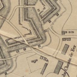
This image contains one map, with ID 25b0d49e1b659498. The XYZ tile URL of this map is:
And for TileJSON:
Instead of the URL of a Georeference Annotation, you can also supply the URL-encoded contents of the Georeference Annotation using the annotation URL parameter:
And for TileJSON:
All PNG and TileJSON URLs are also available in a 512 × 512 pixel retina version. To get retina tiles, add @2x to the end of the URL:
- https://allmaps.xyz/manifests/a0d6d3379cfd9f0a/15/16833/[email protected]
- https://allmaps.xyz/manifests/a0d6d3379cfd9f0a/[email protected]
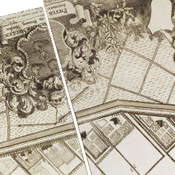
![https://allmaps.xyz/manifests/a0d6d3379cfd9f0a/15/16833/[email protected]](https://allmaps.xyz/manifests/a0d6d3379cfd9f0a/15/16833/10770@2x.png)
| Parameter | Description | Allowed values | Example |
|---|---|---|---|
transformation.type |
Transformation type | "polynomial" | "thin-plate-spline" |
?transformation.type=polynomial |