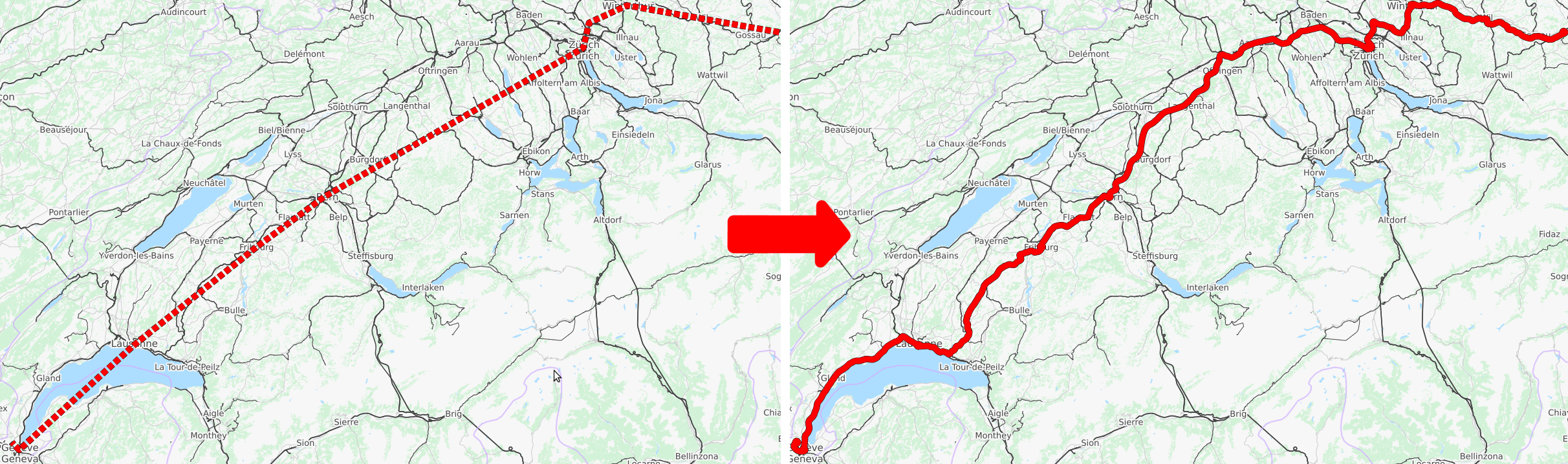
Left: station-to-station path of a single train through Switzerland obtained from official schedule data. Right: path of the same train map-matched by pfaedle.
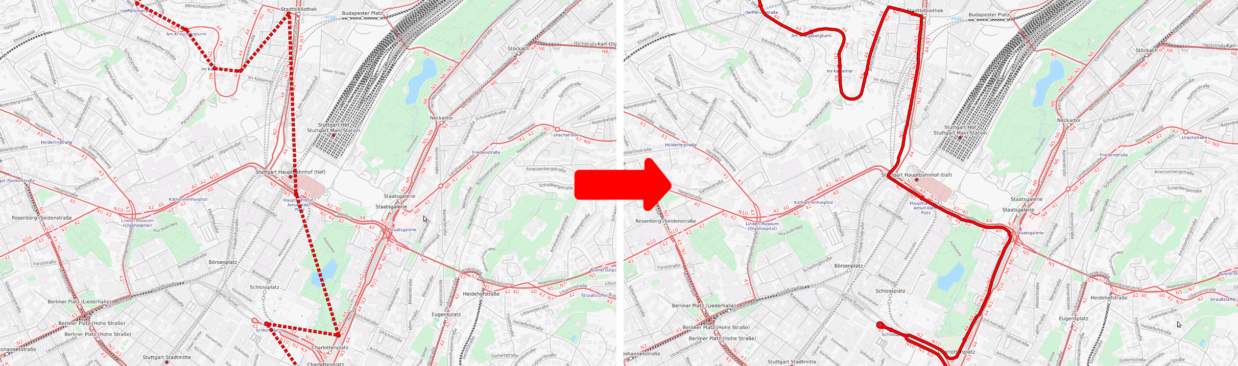
Left: station-to-station path of a single bus through Stuttgart obtained from official schedule data. Right: path of the same bus map-matched by pfaedle.
![]()
Precise OpenStreetMap (OSM) map-matching for public transit schedules (GTFS data). First described in this 2018 SIGSPATIAL paper.
For a quick visual inspection of the shape quality, see for example the schedule data for Germany or Switzerland in our tool TRAVIC.
cmakegcc >= 5.0(orclang >= 3.9)libzip(optional, for ZIP support)zlib(optional, for gzip support)libbz2(optional, for bzip2 support)
Fetch this repository and init submodules:
$ git clone --recurse-submodules https://github.com/ad-freiburg/pfaedle$ mkdir build && cd build
$ cmake ..
$ make -jTo install, type
$ make install$ pfaedle -x <OSM FILE> <GTFS INPUT FEED>The OSM file may be given in the following formats: OSM XML (.osm, .osm.gz, .osm.bz2, .xml, .xml.gz, .xml.bz2), PBF (.pbf).
A shape'd version of the input GTFS feed will be written to ./gtfs-out.
By default, shapes are only calculated for trips that don't have a shape in the
input feed. To drop all existing shapes, use the -D flag.
For example, you may generate (and replace existing, see -D flag) shapes for the GTFS dataset for Freiburg like this:
$ wget https://www.vag-freiburg.de/fileadmin/gtfs/VAGFR.zip
$ wget http://download.geofabrik.de/europe/germany/baden-wuerttemberg/freiburg-regbez-latest.osm.pbf
$ pfaedle -D -x freiburg-regbez-latest.osm.pbf VAGFR.zipTo generate shapes for a specific mot only, use the -m option. Possible
values are either tram, bus, coach, rail, subway, ferry, funicular,
gondola, all (default) or GTFS route type codes (0, 1, 2, 3, 4, 5, 6, 7, or extended route types). Integer codes will only match the specific route type, while string codes will match classes of route types. For example, -m 101 will only match routes with route_type 101 (high speed rail), while -m rail will match any rail service encoded via a standard route_type 2 or an extended route_type describing a rail service (e.g. 100, 101, 102, ...).
Multiple values can be specified (comma separated).
pfaedle comes with the ability to filter OpenStreetMap data. If you specify
the -X flag, pfaedle will filter the input OSM file and output a new OSM
file which contains exactly the data needed to calculate the shapes for the
input GTFS feed and the input configuration.
This can be used to avoid parsing (for example) the entire planet.osm on each
run.
You can use the Docker image by mounting the OSM & GTFS data into the container:
$ docker pull ghcr.io/ad-freiburg/pfaedle:latest
$ docker run -i --rm \
	# mount OSM data
	--volume /path/to/osm/data:/osm \
	# mount GTFS data
	--volume /path/to/gtfs/data:/gtfs \
	# mount default output folder gtfs-out
	--volume /path/to/output-dir:/gtfs-out \
	ghcr.io/ad-freiburg/pfaedle:latest \
	# tell pfaedle where to find the data
-x /osm/osm-data.xml.bz2 -i /gtfs/myfeed.zipThe following flags may be useful for debugging:
-T <GTFS TRIP ID>only calculate shape for a single trip (specified via its GTFS trip id) and output it as GeoJSON to<dbg-path>/path.json--write-graphwrite the graph used for routing as GeoJSON to--write-trgraphwrite the complete network graph to<dbg-path>/trgraph.json
A default configuration file pfaedle.cfg can be found in this repo and will be installed with make install. Custom configuration files can be specified with the -c flag. If no -c flag is set, pfaedle will parse and merge the following cfg files in the given order (if present): <install prefix>/etc/pfaedle/pfaedle.cfg, $HOME/.config/pfaedle/pfaedle.cfg, <CWD>/pfaedle.cfg. Values given in later files will overwrite earlier defined values.
Note that the shapes.txt produced by pfaedle is based on OpenStreetMap data, which is licensed under ODbL 1.0 (see here). If you copy, distribute, transmit or adapt the shapefied GTFS feed, please credit the contributors of OpenStreetMap.