Interaktive Karte mit Verkehrsunfällen mit Personenschaden (2016 – 2024) – Daten der Statistischen Ämter des Bundes und der Länder sowie des BKG, angereichert mit lokalen Metadaten.
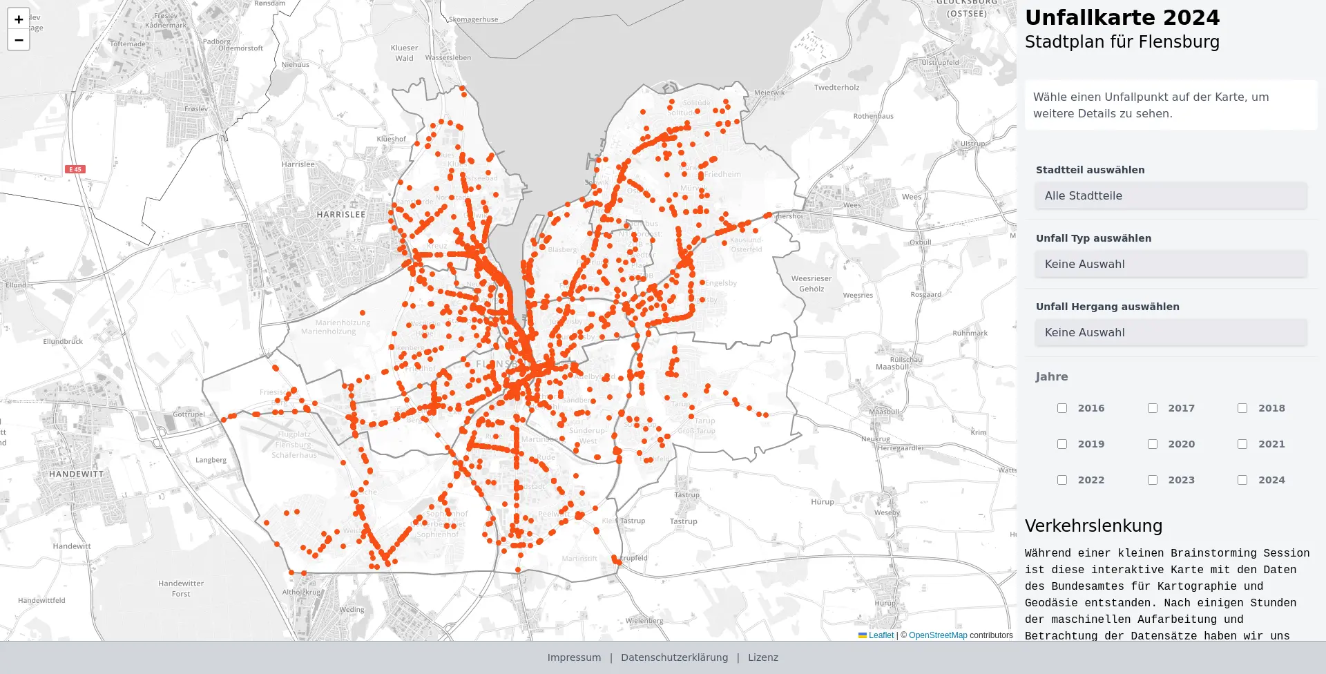
- Nuxt 3 + Leaflet Frontend liefert eine interaktive Karte mit Filtermöglichkeiten und Detailansicht.
- PostGIS-Datenbank hält Unfallpunkte und Metadaten; Import erfolgt über bereitgestellte SQL-Skripte oder GDAL (
ogr2ogr). - Python-Tools unterstützen das Einspielen von GeoJSON-Daten in Postgres.
- Beispiel-Datensätze für Flensburg liegen in
data/sowie als gebündelte Assets unterapp/public/data/undstatic/.
app/– Nuxt 3 Frontend (TypeScript, TailwindCSS, Leaflet) inklusive Seiten, Komponenten und Konfiguration.data/– Beispieldaten (accidents_YYYY.geojson) und das Schemade_accident_meta_schema.sql.static/– Statisch ausgelieferte GeoJSON- und Icon-Dateien (Bestand aus der vorherigen Implementierung).tools/– Python-Skript und Virtualenv zum Import von GeoJSON-Unfalldaten in Postgres.CONTRIBUTING.md– Hinweise zur Mitarbeit.
Frontend
- Node.js ≥ 20 (getestet mit 20.x) und
pnpm(oder alternativnpm/yarn). - Optional:
NUXT_INLINE_SCRIPT_NONCE, wenn ein CSP-Nonce gesetzt werden soll.
Datenimport / Backend
- PostgreSQL 15/16 mit aktivem PostGIS-Extension-Pack.
- GDAL (
ogr2ogr) für das Importieren der amtlichen Shape-Dateien. - Python 3.10+ inkl.
pip/venvzum Ausführen der Skripte intools/. - Komplettinstallation der Debian/Ubuntu-Pakete (Beispiel):
sudo apt update && sudo apt install wget unzip postgresql-16 postgresql-postgis gdal-bin python3 python3-venv git git-lfs
cd app
pnpm install
pnpm dev- Standardmäßig läuft die Entwicklungsinstanz auf
http://localhost:3000. - Produktions-Builds mit
pnpm buildundpnpm preview, oder statische Ausgabe viapnpm generate. - Die API-Basis ist in
app/api/config.jskonfiguriert (https://api.open-accident-map.de/query/). Passe sie bei Bedarf an eigene Backends an. - Frontend-Daten werden aus
public/datageladen. Weitere Kommunen lassen sich hinzufügen, indem ihre GeoJSON-Dateien dort abgelegt und entsprechende Fetches z. B. incomponents/AccidentMap.client.vueerweitert werden.
sudo -u postgres createuser --pwprompt oklab
sudo -u postgres createdb -O oklab oklab
psql -d oklab -c "CREATE EXTENSION postgis;"
Alternativ können bestehende Benutzer und Datenbanken genutzt werden.
psql -U oklab -h localhost -d oklab -f data/de_accident_meta_schema.sqlDas Script erzeugt Tabellen für Unfallkategorien, Lichtverhältnisse, Beteiligte usw. und füllt sie mit Lookup-Werten.
Seit den Daten des Jahres 2024 verwenden die Shape-Dateien neue Tabellennamen und Ordnerstrukturen. Der Import erfolgt pro Jahr:
wget https://www.opengeodata.nrw.de/produkte/transport_verkehr/unfallatlas/Unfallorte2024_EPSG25832_Shape.zip
unzip Unfallorte2024_EPSG25832_Shape.zip
ogr2ogr -f "PostgreSQL" PG:"host=localhost port=5432 dbname=oklab user=oklab" -lco GEOMETRY_NAME=geom -lco SPATIAL_INDEX=GIST -lco PRECISION=YES -nlt POINT -append -nln de_accident_points -s_srs shp/Unfallorte_2024_LR_BasisDLM.prj -t_srs EPSG:4326 shp/Unfallorte_2024_LR_BasisDLM.shp

wget https://www.opengeodata.nrw.de/produkte/transport_verkehr/unfallatlas/Unfallorte2023_EPSG25832_Shape.zip
unzip Unfallorte2023_EPSG25832_Shape.zip
ogr2ogr -f "PostgreSQL" PG:"host=localhost port=5432 dbname=oklab user=oklab" -lco GEOMETRY_NAME=geom -lco SPATIAL_INDEX=GIST -lco PRECISION=YES -nlt POINT -append -nln de_accident_points -s_srs shp/Unfallorte_2023_LR_BasisDLM.prj -t_srs EPSG:4326 shp/Unfallorte_2023_LR_BasisDLM.shp

wget https://www.opengeodata.nrw.de/produkte/transport_verkehr/unfallatlas/Unfallorte2022_EPSG25832_Shape.zip
unzip Unfallorte2022_EPSG25832_Shape.zip
ogr2ogr -f "PostgreSQL" PG:"host=localhost port=5432 dbname=oklab user=oklab" -lco GEOMETRY_NAME=geom -lco SPATIAL_INDEX=GIST -lco PRECISION=YES -nlt POINT -append -nln de_accident_points -s_srs shp/Unfallorte2022_LinRef.prj -t_srs EPSG:4326 shp/Unfallorte2022_LinRef.shp

wget https://www.opengeodata.nrw.de/produkte/transport_verkehr/unfallatlas/Unfallorte2021_EPSG25832_Shape.zip
unzip Unfallorte2021_EPSG25832_Shape.zip
ogr2ogr -f "PostgreSQL" PG:"host=localhost port=5432 dbname=oklab user=oklab" -lco GEOMETRY_NAME=geom -lco SPATIAL_INDEX=GIST -lco PRECISION=YES -nlt POINT -append -nln de_accident_points -s_srs Unfallorte202_EPSG25832_Shape/shapefile/Unfallorte_2021_LR_BasisDLM.prj -t_srs EPSG:4326 Unfallorte202_EPSG25832_Shape/shapefile/Unfallorte_2021_LR_BasisDLM.shp

wget https://www.opengeodata.nrw.de/produkte/transport_verkehr/unfallatlas/Unfallorte2020_EPSG25832_Shape.zip
unzip Unfallorte2020_EPSG25832_Shape.zip
ogr2ogr -f "PostgreSQL" PG:"host=localhost port=5432 dbname=oklab user=oklab" -lco GEOMETRY_NAME=geom -lco SPATIAL_INDEX=GIST -lco PRECISION=YES -nlt POINT -append -nln de_accident_points -s_srs Shapefile/Unfallorte2020_LinRef.prj -t_srs EPSG:4326 Shapefile/Unfallorte2020_LinRef.shp

wget https://www.opengeodata.nrw.de/produkte/transport_verkehr/unfallatlas/Unfallorte2019_EPSG25832_Shape.zip
unzip Unfallorte2019_EPSG25832_Shape.zip
ogr2ogr -f "PostgreSQL" PG:"host=localhost port=5432 dbname=oklab user=oklab" -lco GEOMETRY_NAME=geom -lco SPATIAL_INDEX=GIST -lco PRECISION=YES -nlt POINT -append -nln de_accident_points -s_srs Shapefile/Unfallorte2019_LinRef.prj -t_srs EPSG:4326 Shapefile/Unfallorte2019_LinRef.shp

wget https://www.opengeodata.nrw.de/produkte/transport_verkehr/unfallatlas/Unfallorte2018_EPSG25832_Shape.zip
unzip Unfallorte2018_EPSG25832_Shape.zip
ogr2ogr -f "PostgreSQL" PG:"host=localhost port=5432 dbname=oklab user=oklab" -lco GEOMETRY_NAME=geom -lco SPATIAL_INDEX=GIST -lco PRECISION=YES -nlt POINT -append -nln de_accident_points -s_srs Shapefile/Unfallorte2018_LinRef.prj -t_srs EPSG:4326 Shapefile/Unfallorte2018_LinRef.shp

wget https://www.opengeodata.nrw.de/produkte/transport_verkehr/unfallatlas/Unfallorte2017_EPSG25832_Shape.zip
unzip Unfallorte2017_EPSG25832_Shape.zip
ogr2ogr -f "PostgreSQL" PG:"host=localhost port=5432 dbname=oklab user=oklab" -lco GEOMETRY_NAME=geom -lco SPATIAL_INDEX=GIST -lco PRECISION=YES -nlt POINT -append -nln de_accident_points -s_srs Shapefile/Unfallorte2017_LinRef.prj -t_srs EPSG:4326 Shapefile/Unfallorte2017_LinRef.shp

wget https://www.opengeodata.nrw.de/produkte/transport_verkehr/unfallatlas/Unfallorte2016_EPSG25832_Shape.zip
unzip Unfallorte2016_EPSG25832_Shape.zip
ogr2ogr -f "PostgreSQL" PG:"host=localhost port=5432 dbname=oklab user=oklab" -lco GEOMETRY_NAME=geom -lco SPATIAL_INDEX=GIST -lco PRECISION=YES -nlt POINT -append -nln de_accident_points -s_srs Shapefile/Unfaelle_2016_LinRef.prj -t_srs EPSG:4326 Shapefile/Unfaelle_2016_LinRef.shpDas Skript tools/insert_accidents.py importiert GeoJSON-Dateien in eine Tabelle accidents. Es erwartet eine .env im Projektwurzelverzeichnis mit:
DB_NAME=oklab
DB_USER=oklab
DB_PASS=secret
DB_HOST=localhost
DB_PORT=5432
Installiere die Abhängigkeiten (python -m venv tools/venv && tools/venv/bin/pip install -r tools/requirements.txt) und rufe anschließend z. B. tools/venv/bin/python tools/insert_accidents.py data/accidents_2024.geojson auf.
Für lokale Analysen oder zum Bereitstellen statischer Dateien kannst du die Shape-Dateien auch direkt nach GeoJSON wandeln:
ogr2ogr -f GeoJSON \
  -s_srs shp/Unfallorte_2024_LR_BasisDLM.prj \
  -t_srs EPSG:4326 \
  accidents_2024.geojson \
  shp/Unfallorte_2024_LR_BasisDLM.shp
Das Beispiel nutzt die 2024er-Struktur; passe Pfade für andere Jahre an.
data/accidents_YYYY.geojsonenthält vorberechnete Beispieldatensätze für mehrere Jahrgänge.app/public/data/meta.jsonliefert die Metadaten, die im Frontend zur Auflösung der Codes verwendet werden.static/spiegelt ältere Deployment-Artefakte wider; nutzeapp/public/datafür neue Builds.
Beiträge sind willkommen! Hinweise zu Entwicklungsrichtlinien, Coding Style und Ablauf findest du in CONTRIBUTING.md.
Dieses Repository steht unter der CC0-1.0-Lizenz.